|
|
 Chemtrails Part
4 -
Michael Murphy, Mark McCandlish and Roxy Lopez
lay out the evidence that animal life is being
impacted by this Chemtrail activity that has
been going on in secret for several decades.
Chemtrails Part
4 -
Michael Murphy, Mark McCandlish and Roxy Lopez
lay out the evidence that animal life is being
impacted by this Chemtrail activity that has
been going on in secret for several decades.
|
Chemtrails Part 3
-
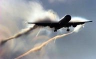
The discussion turns into what kind
of airplanes are being used in
Chemtrailing. Aviation expert Mark
McCandlish joins in the conversation
as Roxy and Michael continue with
their input as well. Various
scientific experiments as well as
military operations are discussed
and information on some the places
where Chemtrail flights are
mentioned.
|
|
Note from Jerry - December 1 as 90 mph wind storms hit Southern California around Foothill Blvd. in Los Angeles and freeways were closed down due to blowing dust storms in the Phoenix area caused by high winds, record snows in higher elevations, one of our producers, Roberta Scott noticed that our Oklahoma sky was full of chemtrails. At about the same time she noticed them in Eastern Oklahoma between Muskogee and Tahlequah, 400 plus miles to the North in St. Louis Chemtrails were everywhere- see the video |

 Chemtrails -
Is This a Project from Hell?
-
Part
Two
-
Jerry continues his conversation
with Roxy Lopez and brings into the
conversation another documentary
investigative film maker, Michael
Murphy, who has a film called, "What
In the World Are They Spraying?" The
discussion gets into evidence of
patents granted for spraying and
weather modification, discussion on
liability factors as one of the
reasons for the secrecy. Murphy
points out population de-population
may also be one of the goals. Jerry
asked if he was saying these people
are
mass murderers and the answer
is surprising.
(some
production values used audio from
the documentary. "Poisoning the
Planet from the Skies" by special
permission of the anticorruption
Society): Chemtrails -
Is This a Project from Hell?
-
Part
Two
-
Jerry continues his conversation
with Roxy Lopez and brings into the
conversation another documentary
investigative film maker, Michael
Murphy, who has a film called, "What
In the World Are They Spraying?" The
discussion gets into evidence of
patents granted for spraying and
weather modification, discussion on
liability factors as one of the
reasons for the secrecy. Murphy
points out population de-population
may also be one of the goals. Jerry
asked if he was saying these people
are
mass murderers and the answer
is surprising.
(some
production values used audio from
the documentary. "Poisoning the
Planet from the Skies" by special
permission of the anticorruption
Society):
|
|
.jpg)
|
|
 Chemtrails-
Is This a Project from Hell?
- Part
One
- Jerry explains some of the things
involved in what is known as Chemtrails,
high altitude spraying of something
and it apparently has been going on
for
Chemtrails-
Is This a Project from Hell?
- Part
One
- Jerry explains some of the things
involved in what is known as Chemtrails,
high altitude spraying of something
and it apparently has been going on
for
 In this first of the series of
programs, Jerry talks with
Investigative
In this first of the series of
programs, Jerry talks with
Investigative |
|
|
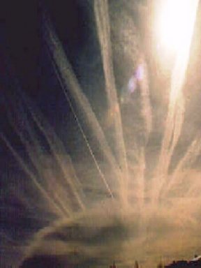
Chemtrails over North
California -
Dispatch
from Mark McCandlish- (March
4, 2011 - 11:15 a.m.
Pacific Time) I guess the real question, then becomes "Why?" Are they afraid to tell us "for our own good", do they know that we are being poisoned for some sinister purpose, or is this a new defensive posture to block the harm caused by some kind of energy weapon being used by the military of another "enemy" country? Now, even today, here in Redding, the aerosol spraying started before sunup. It's only 9AM, and the sky is filled with chemtrails. The forecast on my g-mail home page says it is supposed to be sunny and up to 65 degrees this afternoon. If this was intended to provide some kind of "defense" one would expect that, the process would be concentrated over heavily populated areas, and persist for an given period of time. The fact that it starts before sunup makes me think it either involves radiation from the sun-- thereby requiring that the "shield" be in place before the sun appears above the horizon, or that the temperature change when the sun rises plays a role in the timing of aerosol dispensing. One added note: The chemtrails are "positioned" in our local area. One of the first things we see is a number of trails sprayed to the north and south of the Redding-Red Bluff urban areas and these trails run east to west like some kind of boundary marker. Then the next set of many more trails are dispensed between the north and south markers. This suggests that there are specific areas that are being targeted. Now if this was intended for "protecting" a larger population, it would make sense. But it would also make sense if the goal was to harm, "treat" or expose the largest possible group of people in a given area. I sense that this is the reason discussion of this practice is "verboten". Something is knowingly being done, and if we knew "why" chances are we would not be happy about it and decide against the practice. Mark (markmccandlish@gmail.com) |
|
|
![]()